

Hopkins, G. M. (1878) Atlas of fifteen miles around Baltimore, including Anne Arundel County, Maryland. Philadelphia. [Map]
Retrieved from the Library of Congress
FROM QUAKERS TO WATERMEN:
THE STORY OF DEALE, MARYLAND
This page is a tribute to the rich and diverse history of Deale, Maryland, a charming waterfront community on the Chesapeake Bay and our beloved hometown. From its origins as a farming settlement, then fishing village and summer resort, to its modern-day attractions and challenges, Deale has a lot to offer visitors and residents alike.
We would like to express our gratitude to the Deale Area Historical Society for their invaluable assistance in compiling this information. They generously shared their archives, resources and expertise with us to help bring the past to life. May this page help others to discover something new and fascinating about Deale and its people.

Prehistoric Roots and Indigenous American Heritage

"The Founding of Maryland, 1634". Emmauel Leutze. [Oil on Canvas.]
ABOVE: The Founding of Maryland (1634) portrays the initial settlers interacting with the Yaocomico, a branch of the Piscataway Indian Nation, in what would later become St. Mary's City, Maryland. This location was the first colonial settlement in Maryland.
For thousands of years, people have inhabited the region now known as Southern Anne Arundel County, doubtlessly drawn to the area by its extensive shorelines and navigable creeks, which provided abundant fishing and ports for travel and trade. Archaeologists have found evidence of nomadic Paleo-Indian tribes in the area dating as far back as 8,000 B.C., with a larger, more permanent campsite in nearby West River dating to 2,000 B.C.
European settlers encountered members of the Piscataway nation in present-day St. Mary's County in 1634, at which time the land where Deale now stands was situated in the heart of the hunting territories claimed by the Susquehannock and within the bounds of the land claimed by the Piscataway. Numerous conflicts occurred between the two indigenous groups, who differed in both language and culture. As a result, the land encompassing present-day Deale was never permanently settled by Native Americans, but remained a seasonal hunting ground until a series of intertribal wars and broken treaties with Maryland colonists caused most of the Piscataway groups to flee their ancestral homes in the mid-1600's.
While many artifacts from the Woodland period (1000 B.C. -1650 A.D.) have been found in the area, archeology does not indicate any clear signs of direct interactions between Native people and colonists in this region of Anne Arundel County, except for some brief trading and passing encounters.
BELOW: A painting portraying the encounter between Leonard Calvert (1606-1647) and the Yoacomaco tribe. In this painting, the artist depicts members of the Yoacomaco advising Calvert to consult with the Piscataway Tayac. Father Andrew White (1579-1656) is shown grasping a cross that appears to have been quickly assembled, while two other Yaocomaco observe, one appearing wary of Calvert and White's motives. In the backdrop, two boats carrying settlers are departing from the Ark.


Deale's Quaker Past & Rams Gott Swamp

"Founding of Maryland," Tompkins Harrison Matteson (1813-1884), oil on canvas, 1853. Annapolis, Maryland: State House, Senate Lounge.
ABOVE: In this imaginative painting, Cecil Calvert (Lord Baltimore) stands beside Father Andrew White as he gives the Act of Toleration (1649) to William Stone, the colonial governor. A Native American family is part of the group that observes the event, symbolizing the original inhabitants of the region.
The first European settlers arrived in Anne Arundel County around 1649. Having fled southeast Virginia during the English Civil War to escape religious persecution, they formed a Puritan community called Providence near the mouth of the Severn River.
In 1655, a group of wealthy separatists settled Herring Creek, an area that encompasses present-day Deale. They had converted to Quakerism from Puritanism and other Protestant faiths, due to the influence of missionaries that had arrived in the area. Many farmed tobacco, the valuable and scarce commodity used as a form of currency throughout the colonies.
It was in 1659 that Richard Gott, an Englishman, staked off 600 acres of barren land, which he named "Rams Gott Swamp," and was awarded a land grant from Lord Baltimore. This is the earliest land patent on record for the area.
BELOW: A detail of Augustine Herrman's 1673 map shows the colonial port of Herrington, now known as the area called "Town Point." In the vicinity is Herring Creek, the southern branch of which would later be referred to as "Tracy's Creek." "Gott's Creek," now known as "Rockhold Creek" branches off to the north. The exact time when the names were altered is not known.
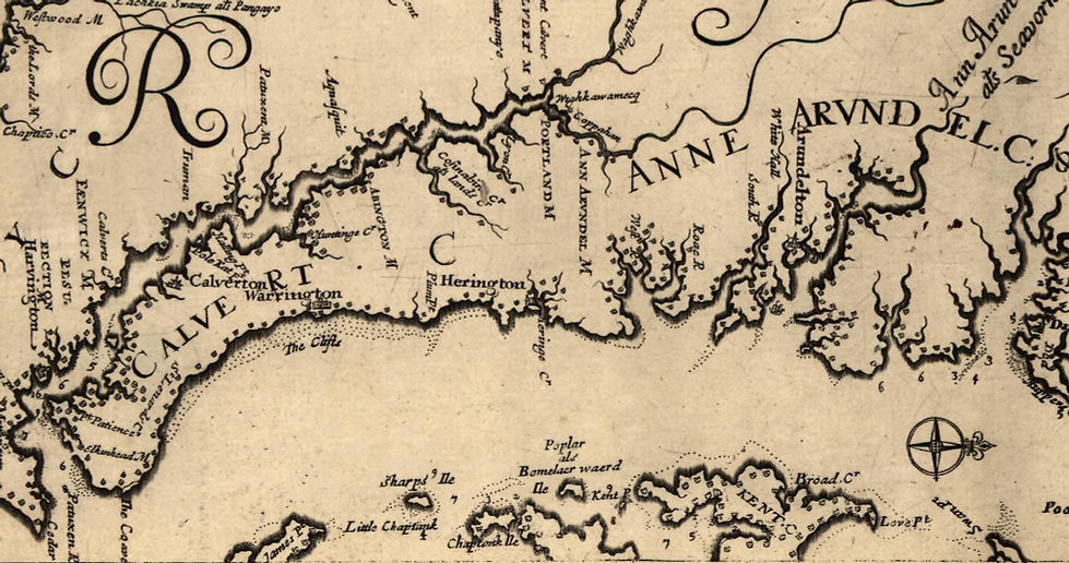
Herrman, A., Faithorne, H. & Withinbrook, T. (1673) Virginia and Maryland as it is planted and inhabited this present year. [London: Augustine Herrman and Thomas Withinbrook] [Map] Retrieved from the Library of Congress.

Between 1659 and 1685, the Gott family cultivated the land for tobacco. In 1685, Richard Gott, Jr., who had inherited the property from his father, started selling portions of the plantation, possibly due to financial difficulties. Approximately 100 acres in the northern area of Deale near Mimosa Cove was kept in the Gott family until 1794. The remaining acreage was parceled off and sold over time, including 240 acres which contains what is now known as the town of Deale.
Family Estates Passed Through Generations
In 1698, Richard Gott Jr. transferred the land currently called Owings Beach and Cedar Point to his wife’s father, Anthony Holland. The property remained in the Holland family until Thomas Holland sold it in 1716 to John Giles, a Quaker farmer. The following year, John Giles purchased adjacent farms, increasing his total land area to 240 acres. Giles would later divide the land equally between his three daughters, but an important acquisition by his son-in-law would reunite the properties once again, giving the future town its namesake.
Photo by Rusty Watson on Unsplash
ABOVE: Tobacco played a significant role in the economy of the American colonies, where it was used as a form of currency. Farmers would grow and harvest tobacco, which they would then sell or trade for goods and services.
BELOW: A detail of Hopkins' 1878 map shows Herring (Tracy's) and "Got" (Rockhold) Creeks, as well as the names of landowners in the region, among them a "J. Deale" in the area marked as Tracey's Landing. Also of note is the identification of Cedar Point and the location of Parker's Island, which is shown here as a peninsula. Parker's Island no longer exists today, destroyed by erosion in the late 1800's, but once played an important role in the formation of Deale.
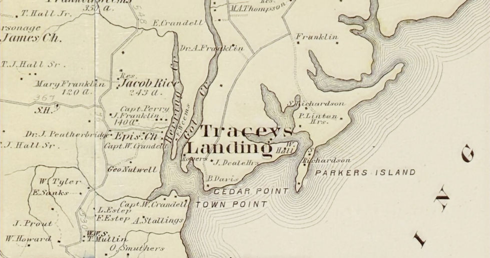
Hopkins, G. M. (1878) Atlas of fifteen miles around Baltimore, including Anne Arundel County, Maryland. Philadelphia. [Map]
Retrieved from the Library of Congress

The Founding of Deale
_edited.jpg)
The family name “Deale” first appears in 1736 when Captain James Deale, who had married John Giles’ oldest daughter, acquired 240 acres of land from the Giles family. The Deales owned the land for nearly 150 years, but it would not be until 1908 that the town bore the Deale name.
After the first bridges over Tracy’s and Rockhold Creeks were built in 1907, the population began to grow. In the following year, 1908, the community then known as Cedar Grove established their first post office, sixteen years after oxcarts transported lumber from Churchton to construct the original Cedar Grove Church. As there was already another Maryland town named Cedar Grove, the first postmaster, John Leatherbury, selected the name Deale after his mother’s maiden name, and the town has gone by this name ever since.
Nutwell, L. (2004). Mrs. Gertrude Phipps (in window), Postmistress, Deale, Maryland Post Office, taken June 3, 1937. A Ripple on the wind: Down the Creek and Along the Shore in Deale, Maryland (p. 27). photograph, Harwood, Maryland; SunDogs Studio.
ABOVE: Deale's post office in 1937. The post office was located at the corner of Drum Point Rd. and Owings Beach Rd.
BELOW: A class photo of the Deale school, c. 1906. The original Deale school building was built around 1889 and was located on Deale Road near the Drum Point Road intersection.

Image Source: Deale Area Historical Society
BELOW: Children of the Phipps family pose for a photo on the original Rockhold Creek Bridge, circa 1912.
.jpg)
Nutwell, L. (2004). Emma Phipps with Henry and Raymond Phipps, on Rockhold Creek Bridge circa 1912. A Ripple on the wind: Down the Creek and Along the Shore in Deale, Maryland (p. 30). photograph, Harwood, Maryland; SunDogs Studio.

Nutwell, L. (2004). Deale Rd. looking toward Cedar Grove Methodist church. A Ripple on the wind: Down the Creek and Along the Shore in Deale, Maryland (p. 30). photograph, Harwood, Maryland; SunDogs Studio.
ABOVE: A view down Deale Rd. in 1935 shows Windsor's Store at the Drum Point Rd. intersection, and Cedar Grove Methodist Church in the same location where it exists today.
.jpg)
Nutwell, L. (2004). view from Drum Pt. Rd. looking toward Mr. Matt Windsor's store at the intersection of Deale Rd. A Ripple on the wind: Down the Creek and Along the Shore in Deale, Maryland (p. 32). photograph, Harwood, Maryland; SunDogs Studio.
ABOVE: Facing west down Deale Road provides another view of Windsor's store, and the original Deale School building is visible to the left of the frame.

Image by Clint Patterson on Unsplash
The Origins of Deale's Watermen and
How Oysters Transformed Deale

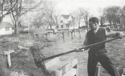
ABOVE: An oysterman uses hand tongs to retrieve oysters from the bottom of the river. Hand-tonging was physically demanding, especially when river depths could be fifteen feet or more. At times, each "lick" of the tongs yielded only a few oysters.
Boats and fishing have always been an essential and longstanding part of the Deale community, but it wasn't until the 1870s that the livelihood of its residents would start to transition from farming to oystering.
The 1800's saw a huge demand for oysters, with scholars likening the frenzy to that of the California Gold Rush. The Chesapeake Bay was the epicenter of the oyster craze, as it was one of the largest oyster-producing bodies of water in the United States. According to legend, the area was so abundant with eastern oysters (Crassotrea virginica) that they caused early colonists' ships to run aground.
As human populations increased around the Bay, so did the rate at which oysters were being consumed, and harvesting innovations made oyster collection more productive. With 19th century advancements in transportation and food preservation, it became possible to ship oysters west by railway, and by the 1840s, oyster canning was a thriving industry in coastal cities-- especially Baltimore.
During this time, oysters were being harvested in massive quantities, and as oysters rely heavily on the presence of the previous generation for reproduction, overharvesting and disease caused population decline, forcing oystermen to travel farther and farther to seek out new beds.
BELOW: Beginning in the early 1800s, dredging equipment was introduced to the Bay and was commonly used on sailing vessels, which enabled oystermen to increase the volume of their catches.
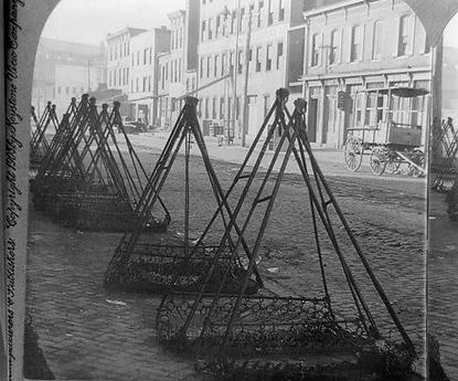
BELOW: Inside a bustling oyster-canning house in Baltimore, oysters are washed, sorted, and prepared for canning. Shuckers use shucking knives to deftly open oysters and pack them into cans.

Food inspector John F. Earnshaw inspecting oyster shucking operation, Baltimore, Maryland. United States Department of Agriculture,
ca. 1914-1915, Arthur J. Olmstead Collection, PP133, Accessed via MdHS.
Oysters: a Magnet for Migrant Watermen

ABOVE: "A Buy Boat. Captain Buddy Sherbert of Deale buying oysters on his Bugeye, The Anna Florence, from Jesse Smith, Sr. at Annapolis Dock."
- caption by Deale Area Historical Society
During the 1850s, watermen from Eastern Shore emigrated to nearby Parker's Island in search of new oyster beds. There, they had discovered the Bay Shore Bar, a huge natural oyster reef that was one of the largest and most productive oyster beds in the Chesapeake Bay at the time. Unfortunately, it was not long after their arrival that they realized the island was eroding away, and by 1890, it had been mostly destroyed by storms. The eight watermen and their families were forced to relocate, many of them moving to the mainland town of present-day Deale.
Meanwhile, the northern oyster industry had become devastated by overfishing and some commercial firms and northern oystermen started to migrate south. Among them, a sea captain named Captain Salem Avery from Blue Point, Long Island, moved to nearby present-day Shady Side in 1857; he spent the next 25 years an oysterman and buy boat captain in the area, working alongside many local watermen, purchasing their catches and taking them to market.
An 1880 census shows that the number of oystermen in the area increased from 11 to 46 in a span of ten years, with citizens of both Irish and German descent entering the area during this time, most likely drawn to the waterman profession, which had low start-up costs and provided a good wage for people willing to work hard. By 1910, the population of watermen in Deale more than tripled in number. Deale’s significance as a maritime town had been well established, and today it continues to lure those who love spending time on the water.
BELOW: Buy boats like the one shown below were essential for transporting freshly harvested oysters from the watermen to local markets and processing facilities.
BELOW: After being harvested or purchased, oysters would then be taken to processing companies, such as the one owned by Capt. Andrew Manifold in the 1920s and 1930s at the site of present-day Shipwright Marina in Deale.


The Oyster Wars and Depletion of the Bay

The year 1884 saw the peak of Chesapeake oyster harvesting, with around 160 million pounds of oyster meat being harvested annually, and hundreds of skipjacks now sailing the Bay to satisfy the ravenous demand. Around the turn of the 20th century, the Chesapeake Bay began to suffer from overfishing, and by 1900, the large harvests of fish and oysters had begun to severely diminish.
Competition for oysters led to lawlessness, and with violence and piracy on the Bay rampant, government officials responded by launching the Maryland Oyster Navy, which would later become the forerunner for today’s Natural Resources Police. Ultimately, with oyster populations dwindling, there was eventually not enough to fight over, and the Oyster Wars finally ceased in the mid-20th century.
The scars of the Oyster Wars persisted long after the conflicts subsided, with watermen facing economic hardships, family stress and emotional strain as they grappled with the aftermath. In the wake of these wars, watermen's resilience and adaptability became their greatest assets, allowing them to weather the storm and continue their age-old occupation on the Chesapeake Bay.
LEFT: Engravings in an 1880 publication portray the tumultuous confrontations, violence, and piracy occurring on the Chesapeake Bay during the Oyster Wars.

Image Courtesy of Deale Area Historical Society
The Watermen Era and the Rise of a Recreation Destination
Nutwell, L. (2004). "Oysters brought $2.50 per bushel this year," Cecil Marshall, 1944. A Ripple on the wind: Down the Creek and Along the Shore in Deale, Maryland (p. 37). photograph, Harwood, Maryland; SunDogs Studio.
ABOVE: A waterman with his oyster tongs in 1944, on the eastern shore of Rockhold Creek, near Drum Point.

Steamer “Emma Giles” at Chalk Point Wharf, Md. (n.d.). photograph. Retrieved March 13, 2024, Source.
For nearly one hundred years, the people of Deale earned their livelihoods around the water, working the waters of the Bay and its tributaries. Families fished, oystered, and farmed together, with men primarily sailing the boats to bring in the catch, and women shucking oysters, cleaning fish, sewing sails, and keeping house. However, the twentieth century brought changes around the Bay that would have lasting impacts on the town’s inhabitants for generations to come.
As early as the late 1800’s, Southern Anne Arundel County had become a tourist destination, with the invention of the steam ship making travelling around the Bay easier than ever before. Steamboats like the “Emma Giles,” a side-wheeled steamer launched in 1887, carried cargo and passengers from Baltimore to many towns and resorts around the Chesapeake Bay, among them nearby Galesville, Chalk Point, Fairhaven and Chesapeake Beach. By the 1930s, the “Emma Giles” was making five trips per week from Baltimore to the present-day Shady Side peninsula, which later became one of the most popular summer resort areas in the County.
LEFT: Steamship "Emma Giles" arriving in Chalk Point, unknown date.
BELOW: Guests of the Phipps family on their way to meet the Emma Giles at Chalk Point. (Nutwell, 2004.)

Nutwell, L. (2004). Going to Chalk Pt. to meet steamer “Emma Giles.” A Ripple on the wind: Down the Creek and Along the Shore in Deale, Maryland (p. 29). photograph, Harwood, Maryland; SunDogs Studio.
Transportation Innovations Attracted Visitors

Image Source: Deale Area Historical Society
ABOVE: An excerpt from a vintage postcard for Deale shows the Rockhold Creek Bridge when it opened for cars in 1929.
.jpg)
Nutwell, L. (2004). "Ida Mae Welch, getting ready to cook crabs, late 1930s." A Ripple on the wind: Down the Creek and Along the Shore in Deale, Maryland (p. 35). photograph, Harwood, Maryland; SunDogs Studio.
With the invention of the Ford model T in 1908, innovations in boating and transportation made watermen less reliant on sails, and motorized boats became more prevalent over time. The growing popularity of cars led to road improvements, with the first state road being built in 1910, and visitors from Annapolis, D.C., and Baltimore flocked to the area, providing watermen with a new lucrative market: recreation.
Boarding houses had become popular in Deale, such as the one operated by Mrs. Lina Parks on Rockhold Creek, or the Roberts family boarding house in Owings Beach, both of which were active in the early 20th century. These houses entertained weekend guests and summer visitors from Washington, D.C. and its suburbs, with some even running local boat tours.
Local watermen sold crabs to feed the boarders, and many enterprising watermen and their families seized the opportunity presented by this emerging leisure-time market, engaging in related maritime trades. Boatbuilding, boat repair, boat rental, and boat storage businesses started to appear, eventually expanding to include recreational fishing charters in the 1950s and 60s.
LEFT: Watermen's wives played a critical role, cleaning, sorting and preparing seafood for sale or consumption. Some operated boarding houses or inns, which provided lodging and meals to travelers. The wives managed accommodations, cooked meals, and maintained a welcoming atmosphere.
BELOW: "Boatbuilding at Capt. Jimmy Rogers, circa 1930s." Boatbuilding businesses like the one at Captain Jimmy Rogers' property on Drum Point Rd. provided an alternate avenue for watermen to earn a living.
.jpg)
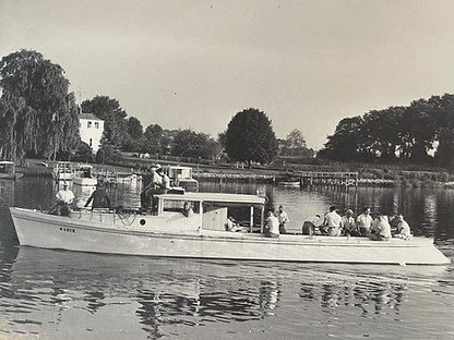
BELOW: Boats that once served watermen in their daily labor were repurposed and adapted for a new role: hosting fishing charters. Pictured is Capt. Toby Welch taking a party fishing out of Gus Berlitz's pier, circa 1954.
BELOW: Captain Johnny Manifold, standing to the left, captained fishing charters during the 50s and 60s. Shown here with his patrons and their catches after a successful fishing trip.

Changing Times: Navigating a Shifting Tide

Fun Fact: In 1952, the Chesapeake Bay Bridge was the world's longest continuous steel structure entirely over water, spanning 4.3 miles shore to shore.

ABOVE: Summer cottages like the ones depicted above became commonplace in the area beginning in the 1920s. In 1933, a powerful storm wreaked havoc on the properties in Mason's and Owings' Beaches, and large portions of front yards were swept away, as documented in this photo following the storm.
Image Courtesy of Deale Area Historical Society
Family land once used for farming tobacco was subdivided into smaller lots in the 1920s, and many of the Roberts' boarders became citizens of Deale by building new homes in Owings Beach. Summer cottages began to line the shore, and the once desolate beaches became populated. Before long, seasonal residents outnumbered full-time residents, with many boaters keeping their boats in the area for weekend use.
Following the second world war, the country enjoyed a time of economic prosperity, with Americans now participating in the expanding middle class, which offered more opportunities for leisure, travel, and entertainment. After the Chesapeake Bay Bridge was constructed in 1952, Ocean City and the Atlantic became more accessible, and the miles of shoreline in South County gradually lost their appeal as a resort destination. However, more highways built in the 1960s boosted Deale's resident population, as people could now live in Deale and commute to Annapolis, Baltimore, or D.C. for work. Many of the summer cottage communities transitioned into neighborhoods of full-time residences.
Times had changed, and the people of Deale were changing along with it. Gone were the days when the waterways were only for working boats used by oystermen, crabbers, and fishermen, and changing attitudes towards the environment combined with regulatory legislation made the fate of the watermen uncertain. Indeed, the legacy of Deale's watermen is a slowly vanishing culture, fading like the tides and leaving behind only echoes of a bygone era.
ABOVE: On July 30, 1952, a motorcade crosses the newly dedicated Chesapeake Bay Bridge. In the lead cars were then-Maryland Governor Theodore Roosevelt McKeldin, Delaware Governor Elbert Carvel, former Maryland Governor William Preston Lane Jr., and their wives. This historic event marked the opening of the bridge, connecting the Eastern shore of Maryland with the state's Western shore.
BELOW: In a vintage travel brochure for Deale, a map guides visitors how to reach the area by automobile.

BELOW: A map of the area in 1957 shows the populated communities of Owings Beach and Masons Beach.

BELOW: A view of Rockhold Creek Bridge from Happy Harbor circa 1970. The wooden bridge was replaced in 1980. The house to the far right of the frame was built in 1932, replacing an older home, both of which were owned by the Welch family. While the house no longer exists today, descendants of the Welch family still live on the property.

Images courtesy of Deale Area Historical Society
"Reeling Through the Years"
BELOW: [Slideshow.] During the 1950s and 60s, fishing charters were a highly sought-after attraction in Deale, often described as a "Fisherman's Paradise." Anglers flocked to the idyllic spot, drawn by its abundant fishing opportunities and scenic beauty.

Images courtesy of Deale Historical Society

Harboring Tradition:
Deale's Journey Toward a Bright Future
Nestled along the scenic Chesapeake Bay, Deale, Maryland continues to attract those who cherish life's more leisurely rhythms. While today's residents of Deale may face challenges distinctly different from those of the early settlers, valuable lessons from history continue to guide us forward, shaping our community's resilience and vision for the future. From the old Nutwell Schoolhouse-turned museum, to the bustling fisherman crowd at Happy Harbor, Deale continues striving to pay homage to its rich history while charting a course toward a vibrant and promising horizon, embracing the winds of change.


A Grateful Tribute to the Community
We extend our sincerest thanks to the Deale Area Historical Society for their assistance in piecing together this treasure trove of information. Their dedication to preserving Deale's rich heritage has illuminated the past, connecting us to the stories, struggles and triumphs of those who came before us.
To all the individuals who graciously answered our questions, shared anecdotes, and took the time to talk about Deale--your passion and knowledge have left an indelible mark. Whether it was reminiscing about the old fishing charters, describing the quaint summer cottages, or recounting the storm of 1933, your contributions have woven a vibrant tapestry of memories.
As we envision the future of Deale, we stand on the shoulders of those who lovingly tended to its roots. May our collective appreciation for this charming town continue to grow, nourished by the bonds forged through storytelling, community and shared reverence for the past.
With heartfelt gratitude,
The Nugent Design Build team

Sources and Additional Reading:
Captain Avery Museum. (n.d.). The Avery House, ca. 1860. https://captainaverymuseum.org/historic-house Cultural Resource Section of the Anne Arundel County Office of Planning and Zoning. (2023, November 9). Historical Overview Region 9 Stakeholder Advisory Committee Briefing Document. Annapolis, Maryland. Deale Area Historical Society. (n.d.). Deale Area Historical Society Archives. https://dahs.us/ Accessed via Interview with Mary Dindino, February 26, 2024. Dybas, C. L. (1998, January 14). OYSTERING in the chesapeake bay : a proud tradition clings to a scarce resource. The Washington Post, p. H01. Retrieved February 28, 2024, from https://www.washingtonpost.com/wp-srv/national/longterm/oceans/stories/oystering011498.htm. Harley-Penny, D. (n.d.). History. The Official Piscataway Conoy Tribe. http://www.piscatawayconoytribe.com/index.php/history Isa, M. (2017, February 7). THE GREAT OYSTER CRAZE: WHY 19TH CENTURY AMERICANS LOVED OYSTERS. MSU Campus Archaeology Program: Protecting Michigan State’s Material Culture. February 28, 2024, https://campusarch.msu.edu/?p=4962 Johnson, R. R. (2018). Dick Johnson’s Archeology and Prehistory of the Deale Area (dissertation). (C.B. Kehler, Ed.). Kehler, Carol Bowman. (2019). Ram Gott Swamp: An early history of Deale, Maryland, Second Edition. Ancestor Encounters. Kimmel, R. M. (2008). Oyster wars: The historic fight for the bay’s riches. Oyster Wars Cannon Historical Sources. https://dnr.maryland.gov/Documents/Oyster-Wars.pdf Marshall, C. (1993). DEALE: a family’s history - a town’s life. South County Life, 20–25. Published by ATM, Inc. Churchton, MD. and accessed via Deale Area Historical Society Maryland on a half shell. Maryland Center for History and Culture. (2014, May 8). https://www.mdhistory.org/maryland-on-a-half-shell/ Matteson (1813-1884), T. H. (1853). Founding of maryland [Oil on Canvas] Maryland State Art Collection. Maryland State Art Collection. Maryland.gov. Retrieved March 7, 2024, from https://msa.maryland.gov/msa/speccol/sc1500/sc1545/apc_website/apcpaintings_foundingofmaryland.html. Meizner, M. J. (1983, August 17). Deale man celebrates his centennial. The Capital Gazette, p. 15. Accessed via Deale Area Historical Society Archives Nelker, M. H. (1969). From the colorful past: deale, part ii: collison’s fire. The Capital Gazette. Accessed via Deale Area Historical Society Archives, 2008. Nutwell, L. (2004). A ripple on the wind: Down the creek and along the shore in Deale, Maryland. Lois Nutwell/SunDogs Studio. The oyster wars of chesapeake bay: How regulatory compromise created conflict: International journal of naval history. International Journal of Naval History | A Global Forum for Naval Historical Scholarship. (2018, November 6). https://www.ijnhonline.org/the-oyster-wars-of-chesapeake-bay-how-regulatory-compromise-created-conflict/#fnref-2455-46 Pruitt, S. (2023, August 10). The post World War II Boom: How America Got Into Gear. History.com. https://www.history.com/news/post-world-war-ii-boom-economy Robinson & Associates, Inc. (2019, October 15). HERITAGE THEMES AND HISTORICAL PRESERVATION PLANNING IN ANNE ARUNDEL COUNTY Theme 8: A Diverse Melting Pot: Ethnic Origins, National Influences, and Immigration. Washington, D.C. Prepared for Anne Arundel County Office of Planning and Zoning, Cultural Resources Division Scenic Rivers Land Trust and Advocates for Herring Bay. (2021). Herring Bay: Landscapes and Legacies. Annapolis, MD; Anne Arundel County’s Historic Preservation Planning Section. Retrieved February 28, 2024, from https://www.aacounty.org/sites/default/files/2023-06/HerringBay-Booklet.pdf. Smith, A. T. (n.d.). Susquehannock Treaty signing. Clio: Your Guide to History. https://theclio.com/entry/144537# Stiehl, C. (2020, August 13). Maryland’s watermen navigate challenges old and new during the COVID-19 pandemic. Chesapeake Bay Program. March 1, 2024, https://www.chesapeakebay.net/news/blog/marylands-watermen-navigate-challenges-old-during-covid Waskom-Pollard, K. (2019, May 31). A brief history of oysters in the Chesapeake Bay. Baltimore Sun. https://www.baltimoresun.com/2014/06/03/a-brief-history-of-oysters-in-the-chesapeake-bay/